

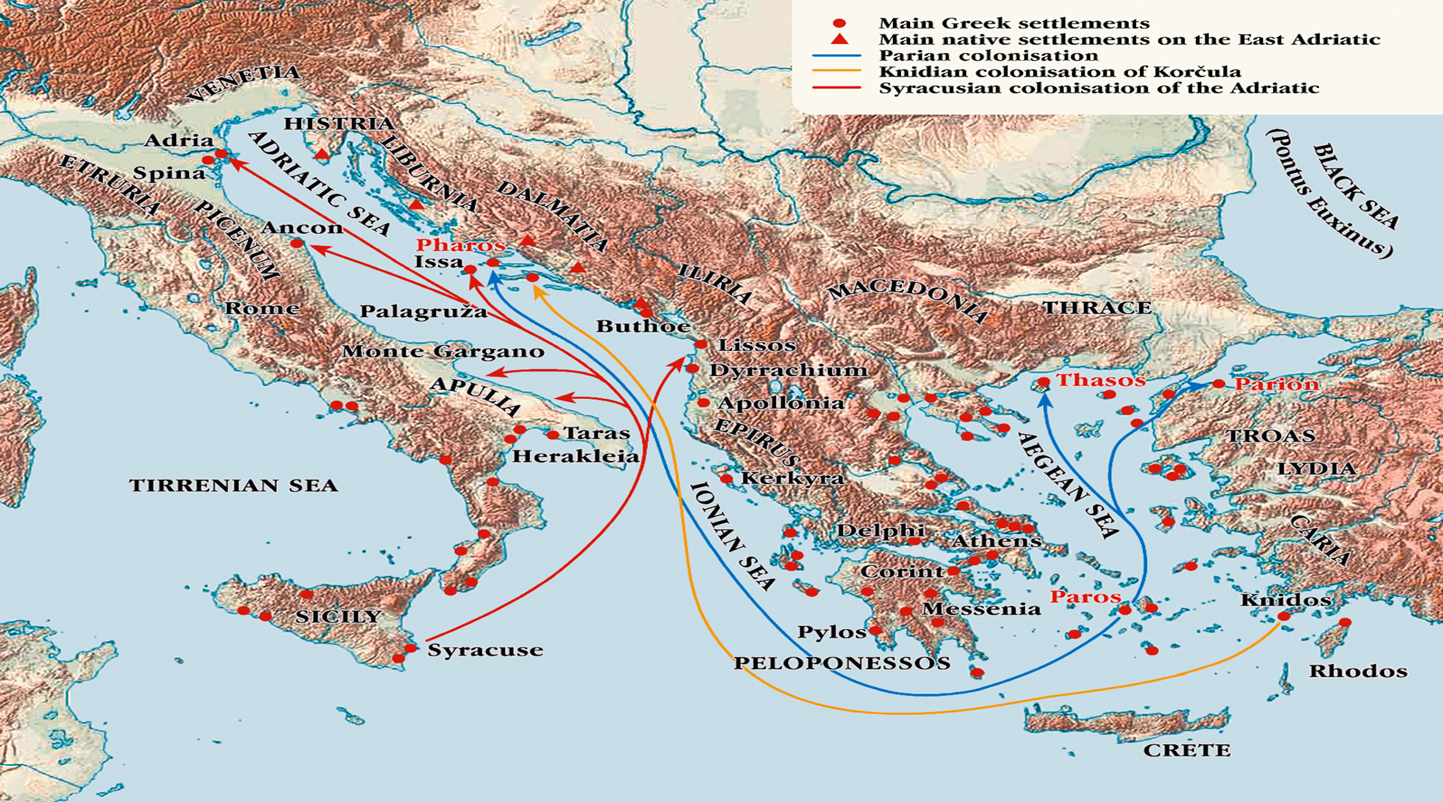
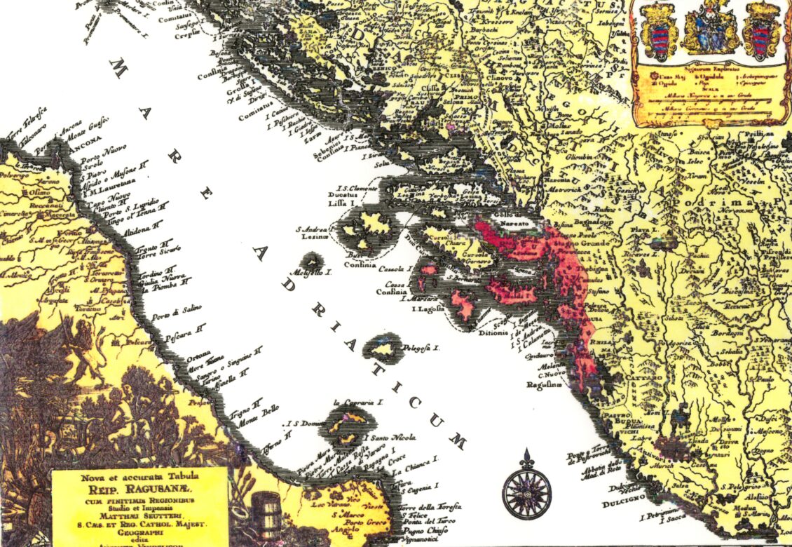
Diomede’s route
The maritime route connecting the Monte Gargano peninsula with the Punta Planka – Diomedes’ Point near Šibenik was named after Diomedes, the Trojan War hero of Homer’s Iliad who sought sanctuary on the Adriatic coast after the fall of Troy. This was the busiest trans-Adriatic route in the ancient world and the Middle Ages and Issa was its most important intersection. Ancient writings, in which historic facts are sometimes interwoven with myths and legends, and archaeological discoveries both on the islands and in the seas below them, form a mosaic hinting at the beginnings of a small but powerful insular world, whose historic significance and destiny have always been determined by sea and navigation.
“Falkuša” boats sailed from Komiža (town on the island of Vis) along the Diomedes’ route towards Palagruža, with maestral (NW breeze) blowing into the stern part of the boat side and returned to Komiža loaded with salted sardine barrels, with jugo (SE wind) also blowing into the stern part of the boat side. The ideal direction of the dominant Adriatic winds maestral and jugo enabled a thousand year long continuity of navigation along the Diomedes’ route.
The famous Greek seafarers brought from their motherland Syracuse to Issa a highly developed artistry in shipbuilding, navigation and fishing. Evidence for this can be seen in archeological finds on Issa, such as the ceramic weights for the nets and hooks made of bronze, dolphin figure on the coins and the mosaic floor of Roman thermae in Issa, as well as fish figures on the Issa vases.
Introduction
The oldest, shortest and most travelled transadriatic maritime route between eastern and western coast of the Adriatic, is the route leading from the Gargano Peninsula and the Tremiti islands in Puglia across the islands of Palagruža and Biševo and the town of Komiža on the southern face of the island of Vis to the Punka Planka Cape, also known as Diomedes’ Cape near Trogir. This route was named after the famous Trojan hero immortalized in Homer’s Illiad, hero Diomedes who, just like Odysseus, sails across the Mediterranean after the fall of Troy, in search of new land which he happens to find on the Gargano Peninsula where he founded a few cities. He also explores the Adriatic by sailing along the shortest transadriatic route along which he finds a sheltered and safe port of Komiža on the island of Vis, as an important maritime station with fresh water springs on its beaches. On this route, almost in its very center is the „treasure island“, still a rather Terra incognita of the Adriatic or unknown land to wider tourist masses, with the largest concentration of natural monuments in Europe – the island of Vis with its archipelago of open sea islands (Palagruža, Biševo, Ravnik, Budihovac, Sveti Andrija, Brusnik and Jabuka).
In the project titled „Creating an Italian-Croatian Network of Small Tourist Destinations“, in order to avoid well known destinations packed with tourists in the high season, and with an aim to first offer the tourist an experience with active participation, and a possibility to use results of already existing local projects tied to maritime tourism, we discover The Vis Archipelago as the central Adriatic Archipelago – a volcanic triangle on the Adriatic which spreads across 7000 square kilometers: from the island of Vis to the volcanic islet of Jabuka on the West and Palagruža on the South. For fifty years this archipelago was closed to tourism due to the fact that it was a Yugoslav military zone from the Second World War until 1989.
The English called Vis „The Gibraltar of the Adriatic“ in the early 19th century, when this island was the only English trade station (porto franco) for commerce with Europe at the time of Napoleon’s Continental Blockade. Vis is also known for an important naval battle which took place off its coast – the first ever naval battle to take place on steel boats, in 1866, in which the Austro-Hungarian navy defeated the powerful Italian armada headed by the „Re d’Italia“ war ship which sunk off the northern coast of Vis where it still lays on the seabottom. In the Second World War the island of Vis was the only unoccupied territory of occupied Europe which Tito’s partisan fighters and their British allies defended against Hitler’s conquerors.
The Gargano Peninsula and the Tremiti Islands
The starting point of Diomedes’ transadriatic route is Testa di Gargano – a cape on the Gargano Peninsula which cuts deep into the Adriatic in the direction of the island of Palagruža. The most important town on its coast is the historical town of Vieste and two smaller towns Rodi Garganico and Peschici with one of Europe’s largest Catholic shrines San Michele Arcangelo in Monte Sant’ Angelo. Today the Gargano Peninsula is a national park with two large lakes Lago di Lesina and Lago di Varano, unique habitats for many bird species. The Gargano National Park also encompasses the Tremiti islands, the only Italian islands in the Adriatic, which are also tied to Diomedes’ name. As far as its geomorphology the Gargano Peninsula is the most interesting part of the Italian coast: Palagruža and Gargano Peninsula once formed the Gargano-Palagruža Adriatic sill.
The Town of Komiža
Komiža’s fishing industry had developed to such an extent that it had no match on the eastern coast of the Adriatic. This resulted in the expansion of Komizan fishermen to countries along the Atlantic Ocean in the early 20th century: their barracks for salting fish in Costa da Morte on the Spanish Galician coast (Finisterre) marked the beginning of Spain’s fishing industry. Martin Bogdanović from the island of Biševo is the greatest industrialist in the world’s history of fishing. These fishermen were pioneers of modern fishing from Chile to Alaska: Californian town of San Pedro became the world’s fishing center due to its Komizan immigrants. The historic urban core of Komiža is a unique example of fishing architecture. All of the houses by the sea were small family factories for salting fish. Komizan fishermen developed and preserved a unique type of fhishing boat – gajeta falkuša – until the mid 20th century.
Komiža is located at the center of volcanic tectonic activity and its beaches with darkgreen rocks and volcanic bombs offer a unique experience and challenge for the geological interpretation of Komizan landscape. Aside from its volcanic origin, Komiža is also known for the abundance of fresh water due to impermeable underground layers. Geo-architectural scapes are also interesting to behold: Komiža’s historic core is predominantly made of stone which had been formed by sedimented shells in gravel and sand. An intrusion of diapir geological structures into Komizan Bay some two hundred and twenty million years ago has pushed this sedimentary rock mass to sea surface. For the largest part the facades of Komiza’s stone houses were constructed from so-called breča or breccia – conglomerate rocks with visible shell crusts. Traces of this primordial sea life are visible on many Komizan house facades.
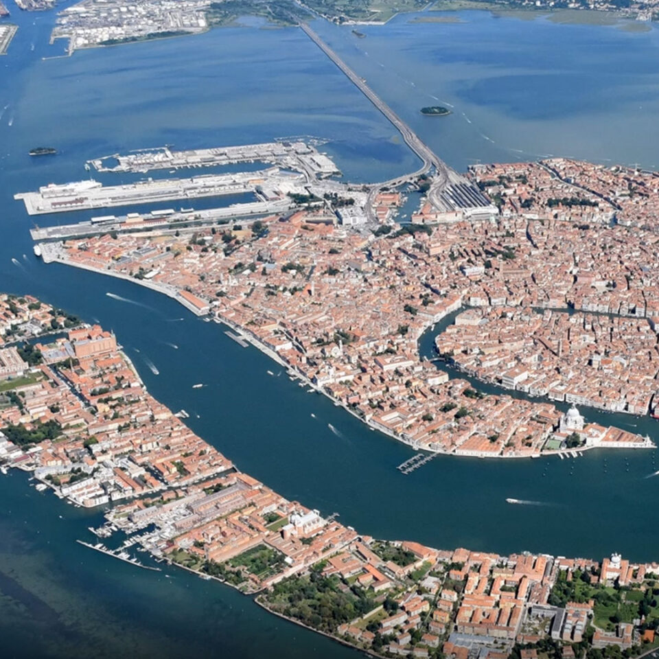
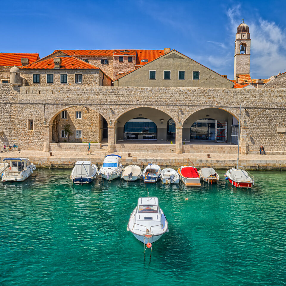
The Town of Vis
The town of Vis is a successor of the Greek settlement or polis called Issa – a city state founded by Dorian Greek colonists from Syracuse. This town was the center of urban civilization on the eastern coast of the Adriatic. It was founded on a slope of the southern coast of the spacious northeastern bay on the island of Vis. A theatre with 3500 seating capacity was built on the Priovo Peninsula. Numerous archeological finds exhibited at archeological museums in Vis and Split are evidence of advanced civilization and cultural development of this Adriatic polis whose afluence derived dominantly from wine production and trade. Wine-growing tradition reaches back to the era of Greek colonists who have planted the first grapevine ever on the Adriatic on this very island. Evidence for this is found also on Issean pottery preserved at the Vis Archeological Museum: lavishly decorated wine jugs (oinohoe) and wine glasses (skifos) as well as numerous amphorae discovered on underwater shipwreck sites off the coast of Vis. The words of Agatarhid, a Greek historian from Cnidus and head of the Alexandrian library (the first half of the second century BC) are perhaps best to describe the importance of wine-growing in Issa: „When compared to others, wine from Issa, an island in the Adriatic Sea, is better.“
The Blue Corridor
Based on undertaken scientific research which has revealed exceptional biodiversity of land and underwater flora and fauna of Vis, the World Wildlife Fund (Rome) has included the Vis Archipelago in the Adriatic Blue Corridor (2003): „Based on international scientific analysis we have proclaimed „The Blue Corridor“ as the zone of greatest biodiversity.“ This corridor includes the islands of Sveti Andrija, Brusnik and Biševo, the northwestern and southeastern part of Vis, including important fishing posts around the island of Sušac, Jabuka and Palagruža.
Paradise Oasis of the Mediterranean
The World Wildlife Fund has also proclaimed the Vis Archipelago one of ten last „Paradise oases of the Mediterranean“, while taking into consideration its natural distinctiveness (monuments of nature, ecological preservation of environment, biodiversity), cultural heritage of previous generations reflected in tangible and intangible heritage, historical references to the island as the crossroads of maritime routes, which has been in the center of great historical events in Europe since Antiquity.
The Greatest Concentration of Natural Monuments in Europe
The Vis Archipelago is a space with the greatest concentration of natural monuments in Europe: The green cave (island of Ravnik), Stiniva bay (southern coast of Vis), The monk seal cave, The Blue grotto (island of Biševo), volcanic islets of Jabuka and Brusnik.
The Blue Grotto
In 1884 a Viennese painter, baron Eugen Ransonnet came upon The Blue Grotto on a small Dalmatian island of Biševo near Vis. He was fascinated and wanted to let the world know about this magical natural phenomenon of the Vis Archipelago. This discovery marked the beginning of tourism on these distant Adriatic islands. The Blue Grotto has since become one of must-see attractions of the Adriatic Sea, visited by more than one hundred thousand visitors anually.
The Monk Seal Cave
The Island of Biševo has a Monk Seal Cave – the longest sea cave in the Adriatic (160 m) that was declared a geomorphological monument of nature in 1967. The cave was named after the Mediterranean Monk Seal (Monachus monachus hermann) species which inhabited the cave until the 1960s.
The Volcanic Islet of Jabuka
Seom thirty nautical miles west of Komiža is a black pyramid-like island protruding from the sea – an islet of Jabuka (eng. apple), declared a geological monument of nature in 1958. This 97 meter tall island with 700 meters in volume is created from subsurface eruptive diorite. Magnetite in Jabuka’s rocks interferes with seafarers’ compasses and navigation around Jabuka is difficult in conditions of poor visibility. In mid 19th century biologist named Visiani discovered an endemic carnation on top of Jabuka (Dianthus multinervis). Of other endemic animal species we must point out Jabuka’s black lizzard (Podarcis melisellensis pomoensis), and of its plant species there is Jabuka’s zečina (Centaurea jabukensis and Centaurea crithmifolia).
The Volcanic Islet of Brusnik
Eleven nautical miles from Komiža and three nautical miles from the island of Sveti Andrija i san islet called Brusnik, protected as a geological monument of nature since 1961. This is an island still rising above the sea which is evident in the conglomerates of pebbles on cliffs high above the sea level. In the middle of the island is a ravine with a natural depression filled by the sea, which the Komizan fishermen used to make salt water pools for keeping lobsters. Remains of fishermen shelters made of large pebbles can be seen on Brusnik’s beach. These small houses provided shelter from the sun and the wind while fishermen salted small pelagic fish in barrels. This is a unique monument of fishermen architecture on these open sea islands.
The Green Cave
This unique cave is located on an islet of Ravnik which is one kilometer away from the coast of Vis, and the cave is located on the west side of its southern coast. The green cave has two large openings so it cannot provide the same light effects as the Blue Grotto. However, its beauty lies high in a small opening in the middle of a tall stone dome through which sunbeams fall onto the water below, reflecting the seabed in the darkness of the cave.
Stiniva Bay
Stiniva Bay on the southern coast of Vis was voted Europe’s most beautiful beach. This magical bay features a lovely spacious pebble beach and is encircled with tall cliffs with a narrow passage towards the open sea.
The Island of Biševo
Surface area of the island of Biševo amounts only to 5,91 km2, and its coast is 18,1 km long. Biševo has 8 villages, in which some 320 people lived before the First World War. Biševo was a wine growing island covered by vinyards planted across large areas of arable sandy soil. Biševo’s world-known plavac mali grape sort produced famous wine sought-after even at the Viennese imperial court. Fishing posts around Biševo were rich with small pelagic fish which the fishermen salted and exported to Venice and Greece. In 1050 a priest from Split named Ivan built a church on top of Biševo’s plateau and consecrated it to St. Sylvester. This pre-Romanesque style church was subsequently handed over to Benedictine monks from the Tremiti islands, who added a monastery to the existing church. One of the oldest paintings of Madonna ever found in Croatia, a 13th century proto-Venetian work (dated in 1220), was preserved in this church.
The Island of Palagruža
Geologically speaking, Palagruža is the oldest island in the Adriatic. Before the dramatic rise of the sea level some 12.000 years ago, Palagruža was a much taller island stretching in the east-south direction for more than 20 nautical miles. On Palagruža geologists have identified a special type of black rock of biomineral origin named pelagozit after Pelagosa (Palagruža), derived from the Greek word Pelagos – meaning open sea. This rock present on Palagruža’s coast indicates Palagruža’s steady annual 2 mm rise above the sea surface. The rise is prompted by the pressure created by two mountain ranges (the Dinarides and Apennines) moving towards each other. For this reason we can also see pebble conglomerates high above the sea level on Palagruža
The Island of Sveti Andrija (Svetac)
Sveti Andrija (eng. St. Andrew) is an open sea island named after the patron saint of fishermen, Saint Andrew. In his well known travelogue called Viaggio in Dalmazia, or Journeys Through Dalmatia, published in Venice in 1774, abbot Alberto Fortis writes down that he believes that the name Pitiea from famous Argonautica by Apollonius Rhodius, a Greek epicist from 3rd century BC, refers to the island of Sveti Andrija, an island which the Greek poet joins to a «loud and thick forested» Issa (Vis) inhabited by Greek colonists from Syracuse. This rather inaccessible island with no bays was home to a large Zanki family who moved to the island from the village of Peschica on the Gargano Peninsula as resin collectors. Until she died a few year ago, Antonija Zanki lived a Robinsonesque life on the island. She was the last inhabitant of the island.
The Benedictine Route
Diomedes’ route named after Diomedes, Trojan hero in Homer’s Illyiad, is also known as the Benedictine route along which disciples of St. Benedict of Nursia, Benedictine monks, founded their monasteries (Vieste, Tremiti islands, Palagruža, Biševo, Sveti Andrija, Komiža, Split). Along this route Christianity crossed from the western to the eastern part of the Adriatic. Biševo’s 11 century Benedictine monastery and Komiža’s 13th century Benedictine monastery were important stations of the Benedictine route between the two Adriatic shores. Komizan oral tradition still keeps memory of the meeting of Pope Alexander III with Komizan fishermen on the island of Palagruža, which is also recirded by his biographer Boson who described this unusual and dangerous journey that Pope undertook. This event happened on March 9th 1177 when Pope’s fleet got caught in strong bora winds on their way to Dalmatia and was forced to stop along Palagruža’s cliffs.
The Bird Corridor
This route is also a bird corridor used by migratory birds for great season migrations. This is the reason for the existence of Eleonora’s falcon’s colony, a very endemic bird species, on the islands of Svetac and Biševo.
The Oldest Regatta in Europe
Komizan fishermen have sailed aboard their falkusa boats along Diomedes’ route for centuries, from Komiza to Palagruža in, in a renowned regatta (the oldest fishing regatta in Europe). In 2009 Cultural Association Ars Halieutica from Komiža revived the historical regatta „Rota Palagruzona“ as a tourist and cultural event. This regatta, in which over one hundred falkusa boats participated once in order to conquer favourable fishing posts on the small open sea islet of Palagruža, has developed into first-class tourist attraction organized at the end of June each year.
Falkuša – the oldest type of fishing boat on the Mediterranean
In 1997 gajeta falkusa boat was restored, as part of the research project undertaken by Ars Halieutica Culture Association. It was restored in Komiža and named „Comeza-Lisboa“ because was planned for her to be exhibited at the World Expo in Lisbon, Portugal. This research included all aspects important for halieutic, cultural and anthropological interpretation which included language, lexicon, oral literature, fishing history, toponymy and antroponymy, boatbuilding, the art of sailing, traditional weather forecast, the art of fishing, gastronomy. The process of declaration of the „experience of falkuša“ as intangible national cultural heritage is underway and soon completed.
Punta Planka –Trogir
The final point of Diomedes’ route is Punta Planka on a peninsula near the town of Trogir whose historic core is included on the UNESCO list of world’s cultural heritage. Trogir was founded by Greek colonists from the island of Vis when they founded their colonies on the shores of Iliricon in the 3rd century BC. It was the town of Tragurion on whose historical core was erected the best preserved Romanesque town in Europe. Within the town walls one can see architecture of Romanesque, Gothic, Reneissance and Baroque style – the most renowned is the Trogir Cathedral with its gateway by master Radovan, the most significant work of Romanesque and Gothic style in Croatia.
Ars halietica
Ars halieutica, cultural association for the research of maritime heritage, was founded in Komiža thirty years ago. Its team of experts researched all of the most important traditional boats of eastern Adriatic, the result of which was the reconstruction of Komizan historical fishing boat called gajeta falkuša which has been representing Croatia for the past twenty years at many world maritime festivals and has crossed 40.000 miles n a mission of promoting Croatian maritime heritage. Ars halieutica revived the historical boat regatta of Komizan fishermen, a regatta from Komiža to Palagruža called „Rota palagruzona“ – probably the oldest historical regatta of fishing boats in Europe, with the idea that this regatta might become a transadriatic one in three parts: from Trogir to Komiža, from Komiža to Palagruža and from Palagruža to Vesta and back along the same route. Our plan is to realize this idea with the project „Rota Diomedea“.


